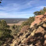
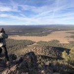
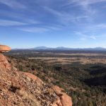
Sure, you’ve seen Red Butte as you drive to the south entrance of Grand Canyon National Park. But, like us, you’ve probably have never stopped. It’s well worth the drive if you’re looking for a sweet hike, with amazing views along the entire 1.25-mile (one-way) trail, interesting geology, and a fire lookout at the top. From the top of the butte, we were able to see the San Francisco Peaks to the south and the North Rim of the Grand Canyon! This is a kid-friendly hike as well, as the trail is short and not too steep until you reach a short area of a few steepish switchbacks before reaching the top.
It’s easy to get to Red Butte (not to be confused with Red Mountain which is off of Hwy 180 nearer to Flagstaff): after turning north on Highway 64/180 at Valle, keep an eye to the east where Red Butte is easy to spot. After about 10 miles, you’ll see a wide graveled Forest Service Road that heads directly east at the southern border of the Kaibab National Forest. The turnoff on FR340 is easy to spot if you keep an eye out. We met some friends at the intersection in early December, and they weren’t able to make the right turn because of a fast car on their tail, so be careful. If you miss the turn, don’t worry, as there’s a place to turn around just a few miles north.
Keep to FR 320 for about 1.5 miles and turn north (left) on FR 340 where there is a sign directing you to the Red Butte trailhead. Travel north along this road for about three-quarters of a mile and at a small sign directing to the trailhead, turn east on a smaller road that dead ends at the trailhead in .25 miles. The trail can be found at the south end of the small parking area. The roads to the trailhead are navigable by any type of vehicle, just take the last stretch a little slow. In wet weather, the roads may become impassable. The trailhead is located at 6,460 feet elevation while the top of Red Butte is at 7,326 feet. There are no bathrooms available at either the trailhead or at the top of the butte.
The interpretive sign at the trailhead tells you about the geology of the Red Butte which is a lava-capped remnant of overlaying rock layers that have been eroded from the surrounding area. The top of the butte is basalt, a remnant of an ancient lava flow that once covered the area. The base of the butte is red sandstone, with a layer of rocks from the Shinarump and Chinle formations above. Red Butte was a place the Havasupai moved to in the winter to hunt game. The Havasupai Nation refer to it as Wii’I Gdwiisa, “clenched fist mountain.” Given its 360-degree views, in more recent times it’s been used as a fire lookout (the original lookout burned down and was replaced in the 1980s with the current lookout). The top of the Butte is entirely flat and there are many social trails between the juniper and pinyon that will take you to the various views.
More information and directions here.
Post written by board member Michele James.